
Engineering Surveying
Within the field of applied geodesy, we offer engineering geodesy services. Engineering surveying for infrastructure projects helps to create 3D CAD models and serves, for example, to preserve evidence. Our services are used both in the planning and design phase as well as during the construction process as a survey during construction and as an as-built survey.
Among other things, we have executed the setting out of roads and sub-surface infrastructure facilities. We also undertake planning, engineering surveys and geodetic preservation of evidence for railroads, canals, bridges, tunnels, water treatment and underground sewers. We also offer 3D surveying of large-scale terrain structures, control surveys for civil engineering, structural engineering and the offshore sector, metrological support for tunnel driving, evidence levelling, and surveys of bodies of water.
Our skilled surveyors assist you for your construction projects with geomatics, laser scanning and other geodesy services. As independent surveyors, our professionals ensure that your surveys are conducted with high precision. We conduct as-built analyses, 3D mapping, surveying your land for civil infrastructure projects.
Depending on your needs, we choose the optimal eingineering survey method for your project and help you to best use the land resources you have. In engineering surveying, we can create for you a custom geographical information system (GIS) to collect and analyse geodetic measurements. We also offer surveying equipment for different types of land and underground construction work.
References
Extention of the D/NL-Emmerich-Oberhausen line
Our performance:
DMT Engineering Surveying GmbH was commissioned to locate, survey and document various infrastructural facilities as a planning basis for the extention of the D/NL-Emmerich-Oberhausen line.
Our client:
DB Netz AG is the rail infrastructure company of Deutsche Bahn AG. It is responsible for more than 33,000 km of track network including the facilities required for operation.
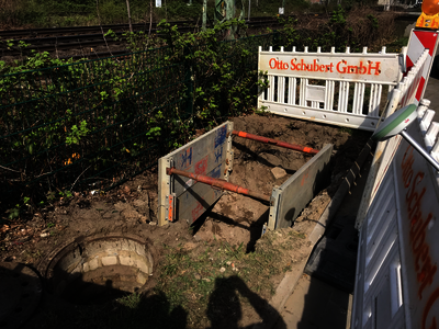
Leither Bach - Construction of a mixed water treatment plant and 4 km long underground sewers
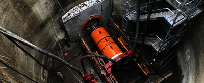
Our performance:
DMT Engineering Surveying GmbH was commissioned to carry out surveying work during construction. This included basic, control and preservation of evidence surveying for pipe jacking, surveying the existing sewers, topographic surveys of the renatured surfaces and surveying 27 shafts and structures with a 3D laser scanner.
Our client:
The Emschergenossenschaft was founded in 1899 as the first German water management association. As a corporation under public law, it is supported and financed by its members - municipalities, industrial enterprises and mining companies. It covers an area of 865 km² and 352 km of watercourses.
Interested in our services in the field of Engineering Surveying? Then please get in touch.
Contact form